Showing posts with label Alpine. Show all posts

6.14.2017

That's Not Alpine Climbing

I've done a lot of rock climbing in the mountains, but I've done very little of the much more specific and serious style that I think should be called "alpine climbing". It's a term that is typically meaningless because no 2 people define it the same way, so we often end up talking past one another and implying different definitions with the same words.

The fancy chart (not to scale on the continuum) lists most of the possible variables people use to decide if a climb is an "alpine" one or not. Many of the variables, such as distance from road/rescue, operate along a continuum, not a yes or no answer. In my opinion a climb needs to be skewed toward the right side of the chart in order to be "alpine", and the exact same route can reasonably be considered an "alpine climb" during some times of year, but a "backcountry rock climb" in mid summer.

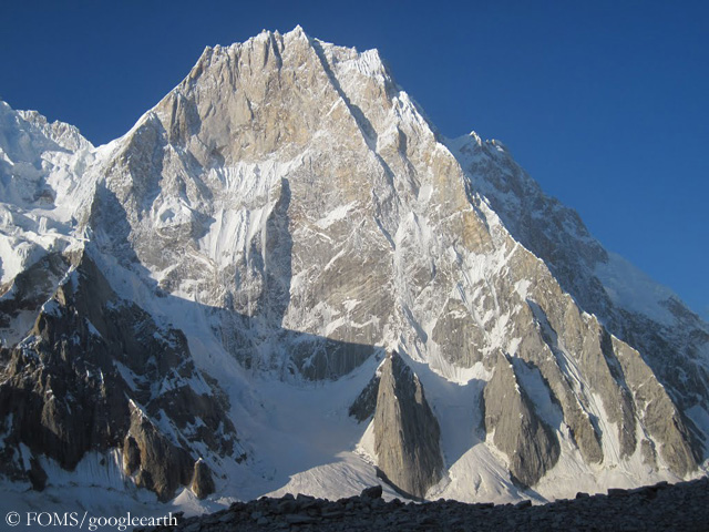
A climb of the N. side of Latok I (none have succeeded) would deal with every single one of the "alpine" metrics/challenges listed above, as well as others I probably forgot about.


A climb of Hallett Peak in Rocky Mtn National Park or Crescent Spire in the Bugaboos won't involve  nearly any of the challenges/metrics above

Just because you are on a rock route at or above treeline, you aren't necessarily alpine climbing and what you are doing isn't likely much different from climb a 600' route in Eldo, or a 1000' route in Red Rock. Most US and Canadian climbers who aspire to succeed on testpiece routes in the Wind Rivers, at the Incredible Hulk, on the Elephant Perch, or on Snowpatch Spire, will benefit from improved rock climbing skills, and shouldn't waste their time focusing on the fairly minor additional challenges presented by alpine elements on these routes. ( an exception for folks with very little backpacking experience at all)

 Phrases like "weather windows" and "speed is safety" are used to describe summertime conditions in places like the Sierra, or the Stuart Range, which don't require one to climb quickly in order to succeed or to be safe, where there aren't summer avalanche or snowstorm worries, daily serac falls, and which generally have warm, calm, and dry weather in the summer, minimal mixed climbing or mandatory steep snow, and solid, popular rock climbs from 4-14 pitches with walk-off or equipped rappel descents. These places (as well as basically everything summer in the lower 48, SW BC, much of the Bugaboos near Applebee/Kain, etc) are more accurately backcountry rock destinations, with some of the peaks and walls in these areas nearly roadside. Colin Haley briefly touches on his alpine definition here, which he specifically provides in order to contextualize his assertions regarding such a vague term - year round snow and ice on route with potential summer new snowfall is a key factor.

We all love to be able to slap labels and categories onto parts of life which are very nuanced. The label allows us to let our guards down and quit spending mental energy on the details. This is especially true when stepping outside our comfort zones where we want to be able to call something simply "safe" or "unsafe", "sketchy" or "bomber", etc and then be done thinking about it. I notice this with climbers asking about the best "trad" shoe, or the best "multipitch" shoe -- both being additional distinct definitions that don't define anything about the climbing or one's footwears. And as summer rolls around in the northwest, it's easy to see and hear folks talking in distinct divides between their "normal" climbing and their "alpine" climbing.

For the vast majority of climbs in the US and Canada referred to as "alpine routes", there are few or no "alpine" challenges. These are usually multipitch rock climbs with nice views and potentially long walks to get to. One doesn't need to put these routes and ranges on a separate pedestal apart from the multipitch rock in places like desert towers, Black Canyon, The Needles, Red Rock, Zion, etc.

If you want to succeed on these routes, I suggest ignoring cardio-first expeditionary style training program like those described in Training For the New Alpinism. (Which is probably an amazing training guide for a separate activity like high altitude mountaineering or ultramarathons or long ski-mo races). Simply be a good rock climber, be good at climbing granite trad pitches specifically, and be good at climbing these trad pitches onsight and quickly, without stressing yourself. Then be in decent enough overall fitness and understand the activity/hobby of backpacking so that you can handle the approach and hike back to the car without getting destroyed or too tired to rappel and descend safely. Don't focus on what you are already good enough at (the hiking, the glacier walk approach, making coffee at 4AM) if it's the difficulty of the movement on rock that will shut you down.

In my time climbing, I'd say that the only "alpine" climbing I've done has been on Fitz Roy and Cerro Pollone in Patagonia, in the Waddington Range and the Stikine of British Columbia, and in the Ruth Gorge of Alaska. I'd actually say that some of the climbing and attempts I've made in Patagonia during good weather have not even been "alpine climbing", as I've tended toward rock-only routes on some of the smaller peaks there, and the area has good rock, published info, no altitude challenges, many fixed anchors, no lightning, much well-protected climbing, and some short routes with easy descents. I've done a couple long Cascades water ice routes but I've never climbed a difficult or committing mixed/mountain route in the Cascades in winter, which I think does including some real alpine climbing, and nothing I've done in the lower 48 or Bugaboos in the summer has had very many of the alpine climbing challenges shown above.

My point is not to have folks simply ignore potential challenges or dangers in their way, and not in any way to attack mountaineering, or backcountry summer multpitch rock climbing, but instead I'm trying to encourage everyone to examine the meaning behind the labels which get thrown around, in order to see what we are all trying to actually communicate. Do these categories make sense to use and hold separate in your mind? You might find that the big, scary, boogey-man term of "alpine climbing" is actually a sheep (or mountain goat) in wolf's clothing.

10.21.2016

The Fine Line of Bailing - 3rd Pillar of Nalumasortoq


I spent August in Greenland, specifically along the Tasermiut Fjord of SE Greenland. The area was breathtaking, with some of the largest granite walls on earth. Despite both succeeding and failing on bigger objectives during our trip to Greenland, the most memorable climb of the trip in my mind is one that ended after just half a day on route, but included nearly everything I love about remote, adventurous climbing on huge mountains and walls. Writing about those ups and downs of emotion and ascension has been much more memorable than simply recounting our team's obvious success or failure. These in-between "gray areas" are where climbing becomes contemplative.

Scott Bennett, Bryan Gilmore, and myself had set out to climb the south pillar (the right, or 3rd pillar) of Nalumasortoq, as seen from our camp along Tasermiut Fjord. We figured that this route would be a fast-drying and great choice for our poor weather, as it had recently rained for 10 days or so, and several of the non-rain days still held fog and swirling clouds trapped against the peaks. We'd left much of our climbing hardware stashed in a boulder cave below Nalumasortoq, and we wanted the fastest-drying terrain in the area, and figured that a SSW-facing overhanging pillar would be it.


A day before we set out to climb, we started up the valley from our camp, and hiked for 5 hours or so up a river valley and across a small rubble-strewn glacier. Amid creaking rocks and receding remnant ice we created a bivy site for our small tent, and took some sunset photos before settling the alarms for very early in the morning. We'd try to climb the 750m 5.11+ route "Non C'é Due Senza Tre" (AKA the Italian route) on Nalumasortoq. Normally a route of that length and difficulty wouldn't be a huge challenge for us, but the huge amount of unknown is what makes remote, expedition, and alpine climbing so difficult. Seldom is the topo (or simple list of length and grade) a complete picture of the challenge. 


This route has a convoluted history, which we didn't know until coming home and doing more research. It was attempted, up to pitch 8, in 1996 by a British/Welsh team. A British climber ended up taking a long fall aiding up P8 and badly injuring his back and leg, resulting in an end to their attempt and expedition. The pillar was "completed" (given a name, and graded 5.11c and A3) by an Italian team 4 years later, and I somehow eventually acquired and read about the route in the 2001 AAJ (published years before I was a climber, but featuring American uber-crusher Mike Pennings on the cover).

 However, 2 years after that, an american team (Steve Su, Ari Menitove, Chris Chitty) attempted a "repeat" and came close to freeing this line, while also realizing that the Italians had almost certainly not completed the route, instead rappelling from a narrow, sweeping ledge 200' below the top. The Americans bivied and finished the route via a very steep, wet offwidth located 60m right of the pillar's crest. Ari and Steve Su were nice enough to fill us in on some beta about the area before our trip. A few years later (in 2003) Americans Micah Dash and Thad Friday made 6 separate attempts over a month to complete the route, and eventually finished the climb (and made an all free ascent) over 2 days. It was 23 pitches, 5.11+ R.  In reality, both the FA and FFA of the "Italian route" were done by American teams. There remained some hardware placed by the Welsh party ('96) the Italians (2000) and the American FFA team (2003). Reading Micah's article about their half-dozen tries on the route, I was reminded of wisdom my partner Bryan had picked up from the great Steve House: "You never get up anything the FIRST time..."

Scott finds the safe path (and avoids the fixed mank)
Our morning of ascent began, as it always does on these alpine starts, with a too-early alarm wakeup,  scalding hot Via coffee gulped down between gluey dollops of oatmeal, and some last-minute packing and wondering if the weather would finally clear. Our previous climb had been an all-frozen and mostly-free (I think Bryan freed the whole shebang) ascent of Nalumasortoq's 'Left Pillar' (650m 5.12+ FFA Martin/O'Neill), its 19 pitches had taken place amid some snow flurries and near-frozen fog with zero sun or blue sky until low on the descent. The three of us donned axes and pons over our approach tennis shoes and made a quick jaunt up a small pocket glacier to the start of the climb. The route began with an amazingly clean and splitter thin hands crack slicing up a scoured slab. Although this would be a 4-star pitch at any crag in the world, all I can remember was how cold my hands and feet were, and trying to race up this splitter without having to take off my shoes and socks or thin gloves. It might have been 5.10- or 5.7, but as pitch 1 of a route of this size, it was just about climbing as fast and casually as possible.

Many or all of the belays were bolted (the route has been rappelled), but a British team had recently ripped half of the p2 belay anchor out of the wall on their attempt. It wasn't clear if the threaded machine bolt ever even had a sleeve on it, or if the sleeve was somehow detached and still in the wall. In order to remedy this situation, we wrapped the bolt shaft in some duct tape and smashed it into the wall with a rock. Alpine shim = Bomber!


After three pitches we did a bit of scrambling and arrived at the base of the main pillar itself, unable to find a belay anchor shown on our topo. Maybe this talus-covered ledge had previously held 10m of snow, which would have allowed us to reach a bleak-looking piton (and maybe one bolt?) anchor now hanging above our heads on an otherwise blank wall, but we found ourselves unsure of where to go. Scott continued leading his block, and wisely chose to follow his own routefinding and FA instinct, beginning on the far right and making a long, loose, marginally-protected traverse left above the (apparently off-route) fixed hardware, gaining a tat-strewn belay perch. Despite having 3 different bolts (all in fairly significant stages of decay) and a possible jingus piece of pro behind a small flake, we hung nervously and gingerly from the 4-piece anchor, which Scott had wisely set very low under this arrangement of dubious anchor points. In retrospect, I think that the 2 completely rusted rivet bolts were relics of the '96 Welsh team, while the mis-drilled aluminum petzl hanger was placed for some free climbing protection in 2002 or 2003, as the start of the next pitch could easily have resulted in a factor-2 fall. Above we could see at least 1 more bolt, but reaching it looked like it would require at least 10m of wet and very difficult face climbing straight above the belay. And given the state of decay, corrosion, and bad location of fixed hardware we'd encountered in Greenland, it wasn't clear if Scott should even climb toward it. Scott eventually climbed straight right off our belay and methodically whittled in a bunch of halfway-decent pro behind flakes and grooves, veering steeply upward and then back left into the bomber corner we'd come to reach. These two pitches involved key routefinding and judgement moments, and I feel like Scott did a great job getting us through them quickly and safely, rather than blindly charging toward the old (off-route, or aid) bolts. Since we were climbing in a team of 3 with 2 dynamic ropes, these pitches actually were dispatched by switching over into half-rope technique mid pitch, and having both followers belaying the leader on one rope each. The overall challenges of these pitches belied their moderate freeclimbing grades.


After a straightforward steep corner, I took the lead for what we though would be the heart of the route - several hundred meters of amazing-looking cracks and corners on the pillar crest. It appeared to have water streaks in many spots, but we were happy to have routefinding challenges over . I began up an immaculate huge white corner, like something out of the Needles in California. Although this pitch was just marked as 5.11c or maybe 5.11+ on our topos, it exemplifies so much that I love about these kinds of routes. Low on the pitch, upon looking up at the long stretch of tips or sub-tips looming overhead, I had Bryan and Scott grab a rock off the belay ledge and clip into into a chalk bag on the tag line. I hauled up the rock while perched on a small stance, and used it to bash vigorously on a couple pitons which were coated in a healthy layer of rust, the only fixed pro on the pitch. The corner looked to remain mostly a seam for the next 50m, but without pitons. Above this point I climbed steadily if nervously. Luckily for me, both sides of the very obtuse corner would occasionally hold a small and squared-off crimp edge, making for great footholds to complement the tips and finger openings. However, I was having a rough time trusting the smears of tiny feet while feeling wool socks, cold toes, and oversized shoes slipping on slick or wet granite. I came very close to trying to bail out of this lead, either by finding a good piece and lowering off, or resorting to aid and taking my shoes and socks off to warm my feet, depump, and get my head together. But I kept whittling away at the lead, and after ~30m I arrived at a small ledge where I could finally get in a bomber red camalot. I'd placed nearly every small cam or RP on our rack (a double set from tips on up), but was still looking at another 100' of the same.

Myself near the end of a long, demanding lead 

Rather than belay on this small sloping stance, I lowered 15m or 20m down the pitch and cleaned most of the small cams that I'd placed. I wouldn't bring up Scott and Bryan to where I was, but instead would keep heading up towards what I hoped would be a bolted belay. In this silly yet fantastic world of trying to freeclimb routes like these, I'd still consider this to be free climbing. Rather than belay up my followers and do 2 separate 30m pitches via natural ledges, I'd resupply with gear from below and then keep going. The friction and rope weight from dragging up 20lbs of ropes would add some real challenge to the top of the corner. To climb the entire 60m without back-cleaning, I think most folks would happily place at least 4 or 5 each blue and green alien sizes.

The next pitch is almost certainly the pitch where the initial Welsh attempt stopped due to a long, injurious fall. I moved 5m up and left from the belay, and found myself peering up a very shallow and obtuse corner, which was running with water. Rather than a finger or hand crack, there was a closed-off seam which wouldn't accept cams, and which featured a string of 4 bashed-in copperheads. Unfortunately, 3 of the 4 had been rusted and broken, no longer featuring a cable to clip as protection. I gingerly reached up and clipped the only remaining head with my tag line, and down-stemmed to the belay. After pulling on the rope with about 15lb of force, the remaining hardware snapped, and the rope came whipping down to the belay. Test result: negative. This pitch had been the aid crux, and also perhaps the mental freeclimbing crux, but had gone free at 5.11a R by Ari Menitove. Micah Dash and Thad Friday had also freed this section. So I hung at the belay staring down at a soaring thin corner I'd just push us through, having climbing past my self-doubts, but now hesitating beneath a short section of climbing that I'd been excited about testing myself on. We had no pitons (though the presence of 4 copperheads gave us doubt that the flare would take pins) and no bolts. If we had bolts, would we feel justified in placing them? Would we feel compelled to ask the Italian non-FA "FA" team? The Americans who actually made the FA and freed this pitch? Or the other Americans (one now deceased) who made the FFA of the whole route? I looked up at the pitch again, tested a few smears along the wet sides of the corner, accepted that we'd have at least 10m of factor-2 terrain above some sharp ledges and flakes, and decided that I didn't want to commit to the corner. Knowing that others before me had sent this pitch, climbers I'd long read about and admired, I was feeling pretty low. As Bryan and Scott both also demurred from committing to the runout, we set up our harness for going down rather than up.

Pouting as we prepare to bail
When the route was freed, the 4 fixed heads above the belay were at most 7 years old. Now they are likely 20 years old and in a natural watercourse, which likely explains why they are all now broken stubs of metal. I'd like to think I can climb 5.11 R, but that day and in those conditions I couldn't. In the end, I think we made the right choice but I will never know if we could have pushed through and sent or not. I'd certainly suggest that the next team bring a few (stainless steel) bolts and hangers.


Movies in the tent


Approaching Nalumasortoq


More nice weather on our climb day

8.04.2014

Home-Field Triple Header

On July 27, Jens Holsten and I completed a long-dreamt goal of climbing 3 peaks in the Stuart Range via 3 different classic modern freeclimbs, each around 5.12a, and doing it in 24 hours.


4.22.2014

Alpine Girth Hitch

Here is a Tech Tip article I wrote for Climbing Magazine. It generated a slew of comments and concerns, some well-founded and other off base.


4.16.2014

Aguja De l'S and Mojon Rojo


After spending a few stormy weeks in the Torres Del Paine, Scott Bennett and I learned that the next 7 days were looking even more stormy! This was bad news as we had only about 10 days left in the trip. Armed with this info and running somewhat low on the tastier food products of our supply, we hiked out of the Torres Del Paine under gigantic loads consisting of packs-strapped-to-packs-strapped-to-packs. We caught the bus back into Puerto Natales and stayed with awesome friends there who run a trakking and kayaking company called Fortaleza Patagonia. They are the most amazing and nicest, most knowledgable guides one could ask for. In addition, both are bilingual. I highly suggest chatting with them if you visit the Paine or Puerto Natales and need local info or want to go kayaking or hiking in the park.

With our friends and a rented Toyota Yaris, we loaded up all our gear and drove (~3hrs) from Natales to El Chalten, where Scott and I thought we would just be bouldering and sport climbing for a week before leaving.

However, after a few days of reacquainting ourselves with actual climbing, a small blip of decent weather showed itself on the forecast for the day or two before I was to take off. We teamed up with a partnerless Steve Swenson, who would have to leave when we did for his return to the states. Steve is a true climbing guru and fount of Himalayan knowledge, and it was great to go climbing with him in the big mountains, not just at a crag in Squamish or Index. The three of us kicked around all kinds of ideas. Given that several accidents had already occurred in Chalten this year, owing (at least in part) to a very limited selection of snow and ice routes climbable between storms, we didn't want to find ourselves queued up behind other parties or climbing a peak we had all done multiple times. We settled on heading (via an approach which was new to all three of us) up to the southern end of the Fitz Roy range.

Scott and Steve - Fitz Roy and Poincenot on the left


We hiked in and left our overnight gear at an amazing bivy boulder/cave a couple thousand feet above Laguna Sucia and ~500' below the edge of the glacier. Nobody was around, which was exactly what we had wanted. The wind was still blowing fairly hard and it was already mid day, so we roped up and brought just a few pieces of gear, eventually rambling up the eastern aspect of Mojon Rojo, which was snow and rock scrambling to a 20' V0 finish. The views over the summit to the Torre Valley were amazing, with wind ripping the clouds through the strainer of the Torres' jagged summits. Armed with knowledge of the glacier and a high camp, we decided to try to climb something early the next morning which we reasonably could manage in gloves and boots.


A few other parties arrived at the bivy cave that evening, but we were the first ones up in the morning and tried to make a b-line for Aguja Saint Exupery. However, we kept running into dead ends in the glacier. After a few attempts at end-running crevasses in the pre-dawn light, we decided that our options were to: A - wait until it was light, and try to re-navigate while probably getting dead-ended. B - try to climbing something on Aguja De l'S which we could reach more easily.
Scott and Steve at the first belay. Aguja Saint Exupery is behind them.
Still following

We settled on option B, and generally followed a combination of the Austrian route (to start) and the Baby Face route for the remainder of the way. After some crotch-deep snow wallowing, I lead up ~100m of steep snow/snice over the bergschrund to build a rock anchor and bring up Steve and Scott. From there I just kept leading, as Scott and Steve quickly followed, often making soup or hot broth or tea at the belays. It snowed lightly all day, but the route was very fun, with interesting and easy ramps and narrow little corners covered in styrofoam snow, but with ample rock pro for both leader and follower. Our line basically traversed the entire east face of the peak from north-to-south, then angled up to the summit pyramid on much easier terrain, before taking 2 final steep pitches to the cumbre. I lead the final 2 pitches with no crampons and 1 ice tool, which, in retrospect, was a bad choice. I had expected more freeclimbable rock but things were very much covered in snow and a thick layer of water ice filled in the cracks. I aided, grunted, and free climbed very slowly as Steve and Scott huddled at the belays and made soup. Highlights included a committing mantle onto a snowy slab with no pro, and a small surprise aid fall, caught with aplomb by the ever-vigilant Mr. Swenson. We took turns standing on the tiny summit being ROCKED by winds from off the ice cap and over the Torre valley, and then downclimbed and rappelled the standard East Face.


Scott and Aguja St. Exupery

We were back in camp before dark and spent a nice night relaxing and asking Steven questions abut his upcoming Karakoram book and his numerous trips to central Asia, and the presence of the abominable snowman claimed to have been seen by Reinhold Messner, et al. For the record, Steve does not, even under intense scrutiny, admit to ever being a yeti.

The next day we hiked out, made pizza in Chalten (dough pre-made and rising during our trip to the mountains) and I caught the bus out of town, with Scott and Steve leaving the next day.


3.14.2014

Torres Del Paine


I spent most of January 2014 in the Torres Del Paine of Chilean Patagonia. It was my first time to this range of Patagonia, and the area has some of the world's most amazing peaks. The three "towers" (north, central, south) are well-known and famous, but the Paine also holds other amazing peaks that are not so visible from the trailhead. These mountains are only about 90 or 100 miles from the vastly more popular (among climbers) peaks of the Fitz Roy and Chalten ranges, so the weather is generally the same in both parks. (very bad) Unlike Fitz Roy and the nearby peaks, accessed by an ever-growing international crowd living in a booming city, the climbing in the Paine almost certainly requires an expedition-style approach, with a backcountry camp, or camps, and no quick access to the outside world.

I was climbing with Scott Bennett, and we had big plans to try and freeclimb routes on the west face of the central tower, such as Wild Wild West (Cosgrove-Smith) or Via Delle Mamme. Unfortunately, the longest decent weather span we had during three weeks was about a day, and things usually take at least that long simply to clear of the ice and snow that accumulates. It was cold and blustery, even snowing in our low camp on a couple of days. We ended up climbing a free variation to the "Vuelo Del Condor" ((Pennings-Tague) on the east wall of the Cuerno Este, but this rock climb, like many on the Cuernos, does not summit. Cuerno is Spanish for 'horn' and the cuernos are peaks which are topped by striking caps of (sometimes very overhanging) horrendously compact and friable shale. There is essentially no snow and ice or gully climbing in the Paine, just steep walls and towers. Unlike the climbing in the Chalten/Fitz Roy area, you can't really go swing tools and wear gloves and boots to climb in marginal days. It's rock climbing or no climbing at all, so the range is less forgiving during very bad weather.


We based out of a low camp in the highest stand of trees the Bader Valley, reached via a ~10-12 mile hike from the trailhead at the Hosteleria de los Torres. This was a remote and beautiful locale, but if you are ever headed to the Paine, we found that the rock quality and freeclimbing options in the Bader Valley, despite being in the center of the range, were generally sub-standard relative to the rock quality in either direction. We wanted to climb a super chossy line somewhere else, and name it "I can't believe it's not Bader." However, this is probably also the most sheltered valley in the Paine, so it could be a good option for very marginal weather windows. The head of this valley is glaciated and has a beautiful alpine lake and a dirty moraine lake, as well as easy access to the peak such as the Cuernos (Este, Principal, Norte) the Mascara, Hoja, Espada, and the South Tower of Paine.

Here are a few good points of beta for climbing in the area:


  • There is no grocery or supply seller anywhere near the park. Buy everything you need in Puerto Natales, and then take a bus to the park with your provisions. The bus ride is ~2hrs.
  • Apply online in advance for a free climbing permit at least a week before you go. You'll need proof of rescue insurance, such as with an AAC membership. 
  • As a climber, you will ride the bus PAST the park entrance, on to the official administration building, then enter and have the park officials sign off that you can go climbing, then re-board the bus, return to the park entrance, and then catch a bus transfer for the final ~15min ride to the trailhead/camping/Hosteria de los Torres. We never saw any rangers or were asked about our climbing gear, so we certainly could have gone without a permit, but if you were to encounter a ranger and not have one, they might turn you back. 
  • Depending on your base camp of choice and climbing area of choice, you may be wise to hire a pack horse (Pinchero) or a porter or to for load-carrying assistance. Most of the climbing is done from the French Valley (Cerro Catedral, Cota 2000, Aleta de Tiburon) or the Silencio Valley or Ascencio Valley (Torres Del Paine). 
  • For help arranging a porter, pack horse, navigating the park rules, or finding a place to stay in Puerto Natales, your best bet is to go see Cristian, the owner of Fortaleza Patagonia in Puerto Natales. He has climbed in the parked and seemingly knows everyone and everything important in the region. The company office is located in downtown Puerto Natales.

8.28.2013

Mt. Bute - West Face Free & Coast Range Adventures


'86 Foweraker-Serl 5.10 A2 
 '13 Herrington-Sorkin 5.12-
The Coast Mountains of British Columbia hold many of North America's most spectacular granite walls and peaks, and are often ignored by alpinists heading (farther) north into Southeast or South-Central Alaska. These peaks are hard and expensive to reach, and seldom very glamorous. I first became aware of one of the range's outstanding peaks, Mt. Bute, several years ago, when a team of three climbers from Squamish won a Mugs Stump Grant to travel there, then succeeded in establishing a monstrous ridge climb gaining roughly 6,000 (School of Rock 2009 Martinello-Kay-Sinnes 5.11 A2). The trio describe Bute's West Face in their Mugs Stump report as "certainly one of the finest pure rock features in the Coast Range; it deserves a free ascent."  


8.27.2013

Bugaboos Pictures


In July I made my first trip to BC's Bugaboo Provincial Park with old friend Nate Farr. We didn't venture onto the Howser Towers or the more remote East Creek Basin, as nearly every day's weather called for some amount of precip. I was impressed with how well-organized and managed the scene at Applebee Campground has become, thanks mostly to BC parks' upkeep and climbers' good wilderness practices. The camping had spots to hang food, metal lockers, posted weather forecasts, well-kept outhouses, and easy access to the big East Face of Snowpatch Spire and the South Face of Bugaboo Spire. For climbs on these features, you only need tennis shoes and a light axe or trekking poles. I never put on my crampons. If you are only doing routes that you'll rappel, bringing big clunky boots will keep your feet dry, but will obviously be a pain-in-the-arch for the steep 3hr hike in.

7.08.2013

Stuart Range Quadruple Header

The immaculate West Face of Colchuck Balanced Rock - climb #1 of the day.
Garrett Grove Photo

I always try a big car-to-car day around the time of the summer solstice, and this year I lured my friend Max Tepfer to come up from central Oregon and join me for a 4-climb linkup in the Stuart Range, close to my home in Leavenworth.

Max is a Smith Rock and Trout Creek crusher who stays in cardio shape guding clients around the Oregon Volcanoes. He had 1 day off work between guiding at Smith, so he was psyched to try for a big crazy day. He was literally in the area for 30 hours, 22 of which were spent climbing. He commuted 6 hours each way to make the day happen, and was onsighting nearly every route.

9.13.2012

Waddington Range - Stiletto Peak, The Blade


While in the Waddington Range we'd hoped to try a new route on the South Face of Asperity, well to the right of the 2011 Elson/McClane route. However, after getting forced onto the rock on a buttress toe below the face proper, we spent 7 pitches and 7 hours in getting dead-ended on plan #2, and we did eventually reach a spot below our original destination, the South face. By this time we'd already dealt with the glacier and ice of the lower Tiedemann/Asperity Couloir in the pre-dawn hours, but a narrow snow couloir we'd have to cross was running with slush-a-lanches and big blocks. We stayed on a shaded rock ledge and watched the evening pass, deciding what to do. Not only did we think that the rock on the South Face was loose and sharp, but also quite blank. Our best options seemed to be the major fractured weaknesses, some of which ran with water. I think that a few thousand years of active glacial scouring along these steep upper couloirs had scraped the wall clean and left few open cracks or holds. Other faces which were higher on the peaks (or not exposed to such active snow/ice scouring) were more climbable. We bailed back to Sunny Knob and had an awesome rest day as the mountains continued collapsing around us.


(We had each placed bets on which bit of the ice fall was next to fall off)

The two new routes that we did climb on the trip were not particularly long (450-500m each on rock above our wandering, mostly non-technical approach via the lower Stiletto Glacier) but they did tackle two of the steepest sections of stone in the area and were done onsight and free with one point of aid. [edit: the above makes more sense if written "onsight and free, apart from one point of aid". ]
Here are a few photos: